
Location data can tell fascinating stories—of where you've been, how you move, and what patterns shape your day-to-day life. But raw GPS data from Google or other sources isn't very readable unless you have the right tools. That's where tools like Location History Visualizer Pro come in.
In this review, we'll break down what LHV Pro is, what it does well, what it doesn't, and how it compares to mobile-friendly apps like FamiSafe if you're looking for real-time tracking and family safety.
Table of Content

Part 1. What Is Location History Visualizer Pro?
Location History Visualizer Pro is a web-based tool that converts your Google Location History data into a beautiful, color-coded heatmap. It's widely used by data enthusiasts, travelers, and analysts who want to see movement trends over time without handing data to third-party cloud services.
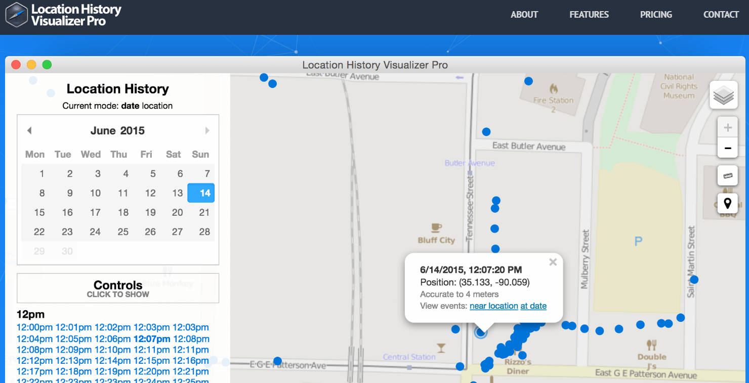
The tool is entirely browser-based and works on Windows, macOS, and Linux. It doesn't require installation, and all processing is done locally, making it ideal for privacy-conscious users.
Some common use cases include:
- Visualizing travel history over months or years
- Mapping movement density across regions
- Generating heatmaps for behavioral or research analysis
One key point: it's not a mobile app, and there's no Android or iOS version available. For those seeking a location history visualizer app, this is strictly a desktop tool.
The base version is free, but if you want high-resolution exports, you'll need the Pro version, which is a one-time payment (more below).
Part 2. Features & Limitations of Location History Visualizer
Location History Visualizer Pro offers a solid feature set that allows you to turn exported data from Google Takeout into rich, interactive maps.
🔍 Core Features:
- Upload Google Location History .json files for visualization
- Choose filters by date, device type, or location accuracy
- Adjust zoom, color gradient, and point density
- Export heatmaps as high-resolution PNGs (Pro only)
- All data is processed locally, no uploads or cloud sharing
- One-time license: $69 for lifetime access
Cannot import live or real-time GPS streams
This makes it great for post-analysis but not for daily tracking or family monitoring.
Part 3. How to Use Location History Visualizer Pro (Step-by-Step Guide)
If you've already requested your Google Location History via Google Takeout, here's how to turn it into a stunning heatmap using LHV Pro:
Step 1: Export Your Google Location Data
- Visit Google Takeout
- Select “Location History” and choose JSON format
- Wait for Google to send your download link
Step 2: Upload to Location History Visualizer Pro
- Open the LHV Pro website
- Drag your .json file into the upload box
Step 3: Customize Your Map
- Select the year, device, and heat intensity level
- Adjust zoom level and point rendering options
Step 4: Preview and Export Your Map
- Free version shows a watermarked preview
- Pro users can download high-resolution PNG files
- Ensure your Google Location is enabled in the original device
- Data with higher frequency (e.g., from daily commutes) creates clearer heatmaps
- Clean up old or corrupt location files before upload
This simple four-step process makes it one of the most user-friendly ways to create a Google Maps timeline heatmap—even for non-coders.
Part 4. Best Alternatives to Location History Visualizer Pro
While Location History Visualizer Pro is great for historical data analysis, it falls short in real-time needs, especially for mobile users or families looking to track children or elderly relatives. If you need live GPS tracking, geofencing, or mobile alerts, you'll want a more comprehensive solution like FamiSafe. It is a mobile-first parental control and GPS tracking app designed for families.
![]()
🌟 Key Features of FamiSafe:
- Live location updates via smartphone
- Location history across days or weeks
- Geofencing: alerts when someone enters/exits defined zones
- App usage & screen time controls
Whether you're a parent monitoring your child's school commute or a caregiver supporting an older adult, FamiSafe adds both safety and real-time insight.
📊 Use Case Comparison
| Feature | LHV Pro | FamiSafe |
| Historical heatmap | ✅ | ❌ |
| Location History | ✅ | ✅ |
| Real-time location | ❌ | ✅ |
| Mobile access | ❌ (desktop only) | ✅ (iOS & Android) |
| Geofencing & alerts | ❌ | ✅ |
| Family monitoring | ❌ | ✅ |
| Data privacy (local only) | ✅ | ✅ (cloud secure) |
Conclusion
If you're looking to analyze past travel patterns, map out your most visited places, or turn raw Google Location History into something visual, Location History Visualizer Pro is one of the best tools available. It's privacy-friendly, easy to use, and doesn't require technical skills.
However, if you're a parent or someone seeking real-time tracking, alerts, or mobile access, LHV Pro won't be enough. In those cases, tools like FamiSafe offer a better solution.
👉 Whether you're visualizing your past or protecting your present, choose the right tool for your goals.
Try FamiSafe for family safety, or explore LHV Pro for data storytelling with your GPS history.
FAQs
Is Location History Visualizer Pro really free?
Yes, it offers a free version for previewing heatmaps. However, high-resolution downloads and advanced features require a one-time $69 purchasef.
Can I use Location History Visualizer Pro on a smartphone?
No. The tool is designed for desktop browsers only. There is no mobile app version available.
Does Location History Visualizer Pro upload my data online?
No. All processing is done locally in your browser, meaning your location data stays on your device and is never sent to external servers.
Are there fully offline tools like Location History Visualizer Pro?
Few tools offer full local processing. LHV Pro is one of the rare exceptions that does not require a server or login.
What's the best way to visualize my GPS history for free?
For quick, basic visualization, use the free version of LHV Pro. For interactive daily use, consider apps like FamiSafe for more control.